


The 2016 Etape du Tour is a 146km ride from Megève to Morzine, taking in four climbs and around 3,335 metres of climbing, according to our calculations.
Megève is a well known ski resort at 1,050 metres height in the Mont Blanc region of the Alps. It was built in the 1920s as a competitor to the Swiss resort of Saint Moritz. It is known for being high end and expensive, so it may not be the easiest place for riders to find cheap accommodation if they want to be near the start.
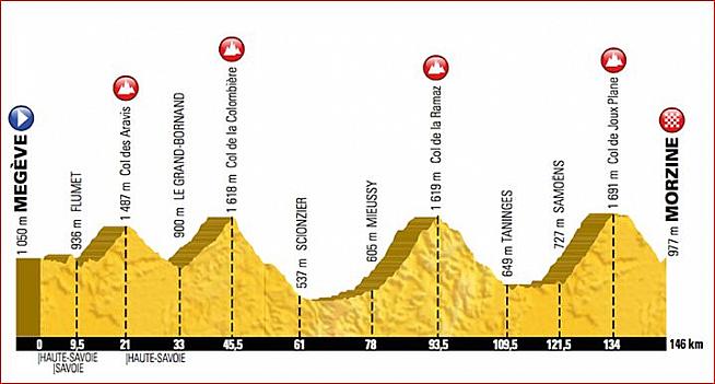
The route starts with a slight downhill section for about 6.5km, followed by a small climb of about 600 metres to get the legs warmed up and then a small descent into the village of Flumet, which stands at 936 metres, after 9.5km. Flumet only has a population of 900 people and is a tiny village but is well known as a crossroads to three big climbs often used by the Tour de France or the Dauphiné (the other two passes for trivia fans are the Col des Saisies and the Cormet de Roselend). The one Etape riders will be attempting is the climb up the Col des Aravis, a 551 metre climb out of Flumet. The Aravis pass has been used frequently by the Tour - this is the 40th time - and is famous for its steep sections.
COL DES ARAVIS
The climb up the Col des Aravis is 11.5km long with an average slope of 5% but, to be honest, those statistics don't do it justice. The initial 1.5km is at 6% and then there is a flat section and 1km of descending before the slope properly kicks in at 4km into the climb. At that point the climbing kicks in and the rest of the way is a test. The next 6km is pretty steady at about 7% (varies between 5.3% and 8.6%) but at 9.8km into the climb there is a short section at a gentle 3.5% before there is about 600 metres at 11.8%. I'd be slightly concerned about whether this will create bottlenecks as some riders will definitely be forced to get off and walk. The final kilometre is a bit easier at roughly 6.5%. The whole of the climb is filled with hairpin bends and goes through beautiful farmland and orchards and should be beautiful to look at; the final kilometre is especially spectacular.
From the top of the Col des Aravis there is a 12km descent down to Le Grand-Bornand with a 587 metre vertical drop. The road is surprisingly wide and with a decent surface so I would expect this to be a fun descent at speed, especially as it is not highly technical. I would expect the first feed station of the day to be located in Le Grand-Bornand, a pretty skiing village that dates back to at least the 16th century. Trivia fans will be pleased to know the locals are called Bornandins.
COL DE LA COLOMBIERE
From here there is a 11.7km climb up the Col de la Colombière. This is a nice climb until the final kilometre. The first 10.7km go at an average gradient of 5.9%, slowly ramping up to 7.5% from 8.7km to 10.7km but the final kilometre is at 9% and is a bit of a slog. It is a very pretty route through Alpine pastures, followed by some lovely rockfaces towards the top. At the summit there will definitely be a feed station as there is a big car park and a restaurant (useful to know about for toilet facilities if you want something a bit better than the disgusting portable loos that are normally on offer). At this stage you will have done 45.5km of the ride and should still be enjoying it!
Off the top of the Colombière you descend for 15.5km, with a vertical drop of 1,081 metres, to Scionzier. The first 7.5km of the descent is steep and quite technical, followed by a lovely, gentle flowing run of 10km into the village. You will need to be careful on the top section, although thanks to the Tour coming through it will have been resurfaced and the tarmac will be clean; it's a tricky descent when it is not!
From Scionzier there is a 17km run along the valley to Mieussy with 68 metres of ascending which should give riders a good chance to get into a bunch and share some work while also having something of a rest before the third climb of the day. I'd expect there to be some sort of stop at Mieussy, possibly just a place to fill bottles and maybe some very basic food such as bananas. The ride should be very pretty as the whole area is a protected nature reserve. Mieussy is just beyond the half way point of the Etape and is also the place where paragliding was invented in 1978.
COL DE LA RAMAZ
The third climb of the day is the Col de la Ramaz which sees Etape riders climb 1,014 metres over 15.5km to the 1,619 metres summit. It has an average of 6.1% slope but that doesn't really tell the full story. The initial 6km goes at roughly 5%, followed by one kilometre of flat, before another kilometre at 8% and then two kilometres at a leg sapping 10.4%. After that you have a kilometre at 8.6%, then two kilometres at around 6.5%. The good news is that the final 500 metres of the climb is almost totally flat. For most Etape riders this will be a tough climb in the heat of the day - you will need to take this steadily and ensure that you are drinking plenty of water because if it is a hot day (and it very often is at this time of year) then the Ramaz will take a lot of energy out of you. For an average Etape rider the total climb is probably around 75 minutes and you should not think of this simply as the warm up to the Col de Joux Plane. The scenery is beautiful - plenty of hairpin bends at the start of the climb, followed by Alpine pastures and then the snow tunnels on the upper reaches. The surface will have been replaced for the Tour, removing one of the main complaints about the ride currently.
Off the top of the Ramaz (we think there will be a feed station at the top but it is possible ASO will decide there is not enough space for anything other than a water station) there is a nice long descent of 16km with a vertical drop of 960 metres. At the top it is a quite narrow road and you will need to be careful if you are surrounded by other riders; fortunately by this stage of an Etape the groups have usually sorted themselves out and you should be riding with people roughly the same speed as you. Towards the bottom of the descent as you get nearer Taninges the road gets wider and it should be a rapid and enjoyable ride. The town itself is not unpretty - it has Roman origins - and we expect there to be a feed station somewhere on the outskirts of the 3,000 population location.
From Taninges there is then a 13km drag along to Samoëns. We imagine you will be routed along the D907, which is mildly uphill (just 78 metres ascent over 13km) but will probably feel like somewhat hard work in the midday sun. You will ideally want to get yourself into a group on this section.
Samoëns is a pretty town, famed for its stonemasonry which were supplied by the numerous limestone quarries in the area. The town is dominated by a pretty (traffic free) square with a huge lime tree and nearby is an Alpine botanical garden. If you want to get your family to come and support you then Samoëns would be an excellent base, especially as it has a reputation for excellent Savoyard food.
COL DE JOUX PLANE
And so comes the final climb of the day. I don't want to scare you but the Col de Joux Plane is a tough old climb. The slopes face south so the full force of the sun will be beating down on you and there is pretty much nowhere to hide. This will be the twelfth time the Tour de France has used this climb, which has been categorised Haut Categorie (ie the toughest) since 1978. It is a climb that has broken some top riders, including Laurent Fignon in 1983 and Lance Armstrong in 2000, who described the day in which he climbed the Joux Plane as "the hardest day on my life - on a bike". It was also the climb where Floyd Landis so memorably destroyed his rivals in the 2006 Tour, four days before he tested positive for doping.
To be totally honest, we were quite surprised to see this stage chosen because of the toughness of the Col de Joux Plan. At 11.6km long with an average slope of 8.5% it is unrelenting. And at the end of a long ride it will be challenging for even the most race fit rider. If you haven't trained enough this will be a climb that finds you out. It starts with about 750 metres at 8.5%, followed by a 12% ramp for 300 metres, followed by a short section at 5% and then two kilometres at 8.5%. A short 'break' of 500 metres at 5% allows a little recovery but then you have 2km at 7%, 600 metres at 10.8% and then follows the last 5km at an average of just over 9% along exposed slopes with absolutely no shelter. Most people who have ridden this will admit that while it is not one of the 'iconic' climbs, the Joux Plane is one of the toughest in the northern Alps. Pantani ascended this climb in 33 minutes - if you manage to do this in double that time then 'chapeau' to you! Personally I rate this as a harder climb than Alpe d'Huez.
When you reach the top the views are spectacular with Mont Blanc dominating the scenery. There will be a feed station (and medical recovery, I'd expect) on the grassy Alpine summit. However don't relax! Although the route map looks like your climbing for the day is finished, in fact what happens is that you have a short descent to the lake, whereupon you must climb another 70 metres to get across the Col de Ranfolly. For those unprepared for this little ascent I can imagine it will be pretty dispiriting.
From the Ranfolly down to Morzine it should be pure joy and relief but you do need to be wary. The 11km descent is at an average of 6.5% with a maximum slope of 11.1% and while it is steep and technical at the top it is also fun. However when you are tired after a long day riding it is something that will test your reflexes and you should not relax and think this is just the final run in to the finish line. There are plenty of tight hairpin bends with steep slopes to keep you occupied. There is a small ascent on the ride into the centre of Morzine to tackle in the final kilometre but if you have got this far the adrenaline will keep you going and the thought of a refreshing beer (or about 16 hours in bed) should take your mind off the pain.
Morzine itself is a typical ski town. It's not the most beautiful in the region and it's a little bit sprawly but if you have a room here then you've done well. Megève to Morzine by road (ie not using the Etape route) is a 55km drive and takes about 1 hour and 15 minutes in normal driving conditions, so if you need to get back to the start it's not ridiculously far away (although I personally would not recommend cycling home, although there always seem to be a handful of hardcore riders who do exactly that).
Gerry Patterson of 44|5 Cycling Tours - one of our recommended tour operators for the Etape - told us after the route was announced: "I'm really looking forward to having the tour in this region. It's outstandingly lovely. The route looks fantastic."
Our feeling is that this is a really proper Etape and one that will test most riders, some to the limit. After a few years in which the ASO seem to have gone a bit easy on Etape riders, this is definitely not the case in 2016. Good luck to all those who are riding and let us know how it goes...
Read Paul Hunt's 2015 Etape du Tour ride report
Read Alex Voake's 2014 Etape du Tour ride report
Read James Andrew's 2014 Etape du Tour ride report
Read Chris Walker's 2014 Etape du Tour ride report
11 Comments