


The Tour organisers have again chosen the Alps for the 2017 Etape du Tour and while it isn't the queen stage of the race (that's in the Jura mountains between Nantua and Chambéry) this day in the saddle is neither short nor lacking in climbing.
The 2017 Etape - which is on Sunday 16 July, 2017 - starts in Briançon, a fortified town with a population of around 11,000 that is the technically the highest city in France at 1,326 metres (based on the slightly odd French defintion of a city being a place with at least 2,000 people). Briançon is a pretty place and a good touristic spot but it doesn't have a huge number of hotels and I think anyone looking for accommodation now is going to struggle as the tour companies will already have booked all the good spots. You might be better off look at Montgenèvre, a 11km drive to the east, which is a ski resort with a decent amount of apartments and hotels, or reading our guide to Etape tour operators.
The other problem with Briançon is that in my experience there is not much car parking space. There is a large car park outside the town on the main road which will be empty early in the morning (assuming it is open) but be warned that there is a steep uphill climb back to it after a long day in the saddle!
The ASO (the Tour de France organisers) have not yet made it clear where they expect to start the Etape from but I'd expect it to be slightly out of the centre of Briançon, somewhere on the N94 road out of town. The Centre Aquatique (the town swimming pool) looks like a suitable start point to me but it is on the wrong side of the river from the main road and so logistically they may consider that to be too tricky.
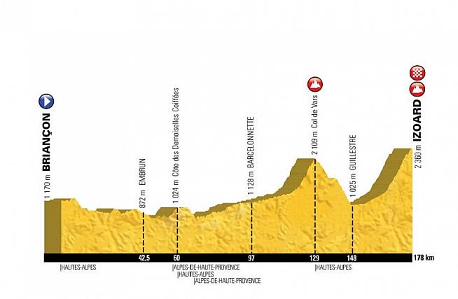
The first 60km of the Etape is almost entirely downhill. 8.5km into the ride there is a small uphill section of about 80 metres of climbing over 2km but otherwise it is a gentle downhill for 60km with a total descent of 205 metres over the 60km ride. I'd expect a lot of riders to go off very fast and for it to feel quite dangerous, especially for those not used to riding in large groups. When I rode my first Etape there was a 20km downhill section to kick off and I looked down at my Garmin after about 5km to find that I was going at 50km/h! With the adrenaline flowing there will be plenty of people absolutely going for it on this initial 60km and the key thing is to not get carried away and burn any matches early on with lots of hard riding to come later on in the day.
After 61km the first climb of the day kicks in and while it doesn't look like much on the route profile supplied by ASO, the Cote des Demoiselles Coiffées is non trivial. It has some very interesting rock formations at the peak which are a tourist attraction but you will probably be more interested that it is a 7.2km climb with roughly 480 metres of climbing at an average slope of around 5.5%, although there is a short steep section at the top of about 11%.
Off the top there is 5.3km descent in which you lose 510 metres of altitude, meaning that the average is around 10%. With riders still likely to be working in large groups at this stage of the Etape, you need to be super careful on the descent and to make sure if you are a cautious descender that you leave plenty of room on your left to allow people to overtake.
At the bottom you will be 74km into your ride and it is here that the climbing of the day really kicks in. From here you have 58km of uphill riding to the top of the Col de Vars. Now don't get me wrong, the ascent is not very steep for most of the time, it's just that it is very long. The ride is along the D900 road and is next to a pretty river, the Ubaye, going through a series of small villages, forests and mountain pastures. You trundle along for about 48km at a slope of about 1.5% to 2% before at La Condamine Chatelard the climb kicks in a bit more, ramping up to 5% for about 9km and then 12% for 1km, 9% for 1km and the final two kilometres at about 12%.
The Col de Vars climb isn't particularly tough by Alpine standards but it's not easy either and if the sun is out in force then by the time most Etape riders get there it will be challenging. Make sure you drink plenty of water and make sure you don't use all your energy on this climb as you will need plenty for the final ascent of the day.
At the top of the Col de Vars you will have ridden just over 130km. There is then a lovely 18km descent at a fairly consistent 5% which should be the most fun bit of the day. By now the field will have thinned out a bit and you should be able to swoop down without too much interference. Just remember to spin your legs a bit so they don't seize up through inactivity.
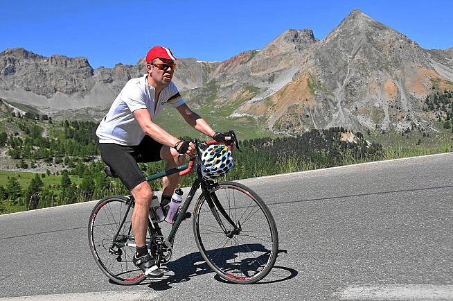
And then with 148km of riding in your legs comes the main course, the ascent of the Col d'Izoard. I have to confess I have not ridden the Izoard from the side that the Etape is taking but having ridden the other side, I can tell you it is a tough old climb to take on. The early sections are actually very pleasant with the first 16km at roughly 2.5% along a narrow gorge road (which is usually packed with cars so you have a rare opportunity to enjoy it vehicle free). This is a good warm up for the final 15km, which starts when the D902 takes the left turn back to Briançon.
From here it is a proper climb. The average slope is 6.9% over 15.9km. The initial stretch up to Arvieux is fine, through open countryside and at around 4% but with sections at 8%+. There is a flat section at Arvieux which gives you a little respite before the steep climbing starts again. At Brunissard, with 6km to go, the open countryside turns to pine forests and the steepness ramps up a little more. From here it will be between 8% and 10% all the way to the top, except for a tiny 300 metres section of downhill about 2.5km from the summit. Out of the forest you hit the moonscape of the Casse Déserte and with 1km to go you pass the monument to Fausto Coppi and Louison Bobet, who battled here so many times in the 1950s. You may not feel in the mood to stop for a selfie in front of it.
In the heat of the early afternoon this will be a tough climb. Good riders will do this course in a little over six hours. For those doing an Etape for the first time, you may well take over ten hours to get round. We will be updating nearer the time on what we expect the time cut offs for the broom wagon to be but my guess is that the last one will be after seven hours at the bottom of the Izoard and then riders will be allowed to finish in their own time.
The Etape website indicates that it is a 178km ride with 3,529 metres of climbing. That makes it one of the tougher Etapes in recent years. With the climbing back loaded to the last 100km of the ride it is particularly tough and if it is a hot day I can see a lot of riders struggling to finish. However it is a proper challenge and one that makes me salivate at the thought of riding it...now to see if I can get permission to escape for a week!
From the summit finish there is a beautiful descent back to Briançon. Be careful though as it is has some tricky bends (although it is not super technical) and you don't want to take too many risks when you are exhausted after a hard ride. The Refuge Napoleon is about 400 metres down from the summit and serves excellent mountain food. You might want to rehydrate with a beer or a Coke and get some proper food before going back to your car/hotel.
Remember too that the pros will be riding the same route on 20 July, four days later. You could do a lot worse than spend some time in the area riding some of the excellent nearby routes - the Galibier is nearby and it's a short drive over to Italy to ride up to Sestriere (don't ride across to Italy though as the road is one of the most dangerous and lorry filled in the Alps) - before seeing the peloton do the same route in about 90 minutes faster than even the best Etape rider.
0 Comments