


Sportive.com's Joe Saumarez Smith analyses the route for the 2015 Etape du Tour. How tough is it and what should you prepare for?
The 2015 Etape du Tour route is definitely one for the climbers. It will be stage 19 of the 2015 Tour de France and the official announcer said that although it was a "condensed stage" it "could be one of the toughest".
The stage is listed as being 142km long, although the official announcer said that the pro riders would be doing 138km, which I guess takes into account a neutralised section at the start. Our calculation is that there is a total of 4,079 metres climbing on the route but it could well be a bit more than that.
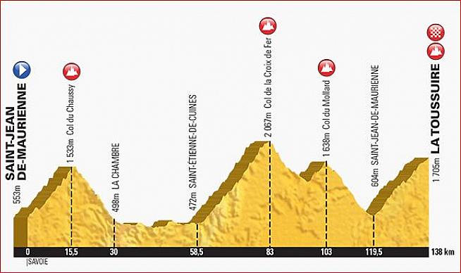
The route takes in three substantial climbs. The first is up the Col de Chaussy, one of the lesser known climbs in the French Alps but a spectacular start to the day, followed by a climb up the Col du Glandon (and then a very short further climb to the top of the Col du Croix de Fer) and finally a tough climb up to the ski station of La Toussuire. If it is a hot day this will be a very challenging ride, even if the distance isn't ridiculously far.
Rolling out of Saint-Jean-de-Maurienne, it looks likely the route will start out along the A43 as it is a nice wide road with a gentle 7km descent down to the village of Pontamafrey-Montpascel. The good thing about the way the start has been structured is that there should not be too many bottlenecks in the race. The wide, closed roads from the start to Pontamafrey-Montpascel will act as a filter for fast and slow riders and the steepness of the early climbs will mean that there is a natural selection of riders. As long as the slower riders remember to stick to the right hand side of the road, everything should work out pretty well, even with 13,000 people allowed to enter the Etape this year (up from 11,500 in previous editions).
From the top of the Col de Chaussy, there is a 1,035 metre descent over 14.5km to La Chambre. With a maximum slope of 12% and an average of 7.4%, this should be a lot of fun. The road surface is rated pretty good and the surroundings are beautiful and it is not too technical a descent, especially by comparison with the way up. My guess is that there will be a feed station in La Chambre.
From La Chambre there is a 28.5km run to Saint Etienne des Cuines, which looks to be along the valley floor and relatively flat. I'm a bit puzzled as to how this works out as the direct route between the two points is much shorter but perhaps ASO, the Tour organisers, needed a bit of a break between climbs or some local town or village has paid a decent wedge of cash to be on the route. Anyways, this will be a flattish section which should be a good break for the legs and a chance to hide in a peloton and get a bit of a rest.
Arriving in Saint Etienne des Cuines, you will find a fairly dull, non descript village. There is a water fountain for refilling bidons but no shops on the route for supplies such as a can of Coke. Here is where the ascent of the Col du Glandon commences. This is a 1,452 metre climb over 22.5km and an average gradient of 7%. However the gradient is a bit of a lie as this is not a steady climb. All the toughest climbing is at the top. The initial 8.5km to the hamlet of Le Villard Martinan is a nice steady climb at about 7%. It is tree lined so will not be too hot, the road is wide and in good condition and if you get into a steady rhythm this will be a lovely introduction to the Glandon. At the hamlet you then have a bit of a break, with a 2km run at no more than 2% to give your legs a break. There is then a return to 7% for about 2km, followed by a leg jarring run of 3km at 9%, 1km back at 7%, 1km at 7.6% and then the final 2km at 11%. There are stretches of the final 2km at more than 12% and with the sun beating down and no protection from the trees above the treeline it will be a serious test for even the fittest rider.
At the top of the Col du Glandon there is a small descent then a further ascent of 143 metres over just under 2km to the top of the Col du Croix du Fer (cross of fire). To be honest, at around 6% you're not going to be feeling this too much relative to the last bits of the Glandon. For clarification, the Croix du Fer is a different mountain on the same range as the Glandon and so technically you have summited two Haut Categorie (HC) Tour climbs!
I'd expect there to be a feed station at either the top of the Glandon or the Croix du Fer but if not there is a very nice cafe at the top of the Croix de Fer, which I can recommend.
Off the Croix du Fer, there is a long descent down back to Saint-Jean-de-Maurienne with a 6km climb in the middle in the way, which is the ascent of the Col du Mollard. Do not be fooled into thinking this is just a small blip. The 6km climb is along tree lined roads and is very pretty but it averages 6.8% as it climbs 403 metres and 5km in there is one ramp at around 11% for about 400 metres. Off the Croix du Fer you have 14km of descending before you hit the Col du Mollard climb and off the top of there you have 16.5km of pure descending back to Saint-Jean-de-Maurienne. I would expect there to be the final feed station of the ride here, although I expect there will be a water station on the climb to La T.
The final climb of the day is 18km with 1,095 metres of climbing, at an average of 6.1% to La Toussuire. The climb itself is pretty uniform, with ramp of 8.8% between kilometre one and three being the toughest part. After that it settles down to 6% or so up to kilometre ten, then between 11km and 12km it is virtually flat, followed by the final 5km between about 5% and 8%, depending on the section. This is not a tough climb by comparison with the earlier climbs on this Etape but with over 120km in the legs before starting this ascent, the temperature will be a big factor. It could well be over 40 degrees heat by early afternoon and you need to make sure you have fed and hydrated yourself in preparation for this sort of climb.
La Toussiere (Les Sybilles) is nothing to write home about in terms of looks. It is a slightly straggly minor French ski resort and won't win many awards for anything. However you will be so relieved to finish that it may look like heaven and a cold beer may taste like nectar.
In summary, this looks like one of the tougher Etapes of recent years. It has one of the legendary climbs of the Tour - the Col du Glandon - as well as some spectacular scenery. Riders will need to do plenty of preparation for their ride and get a lot of mountain rides into their legs, as the 4,000+ metres will be challenging for even the fittest sportive enthusiast.
Read our Etape du Tour overview page with links to other information about the 2015 Etape.
0 Comments